Monthly Archives: May 2021

CC -Day 4 – Wed 19th May – Aviemore to Glenlivet

Wet wet wet. The longest, hardest and slowest day. The stats for my last day:

36.5 miles, of which about 28 were off road ( bog in large part) at a measly 5.2 mph.

Ascent : 3513 ft.

So what fueled my damp experience ?

The Rowan Tree breakfast, winner of the mtb Cairngorm tour prize.

An excellent omelette, good coffee, homemade marmalade, yoghurt, granola and fruit. Toast too. Maybe eating all that was why I was so slow…

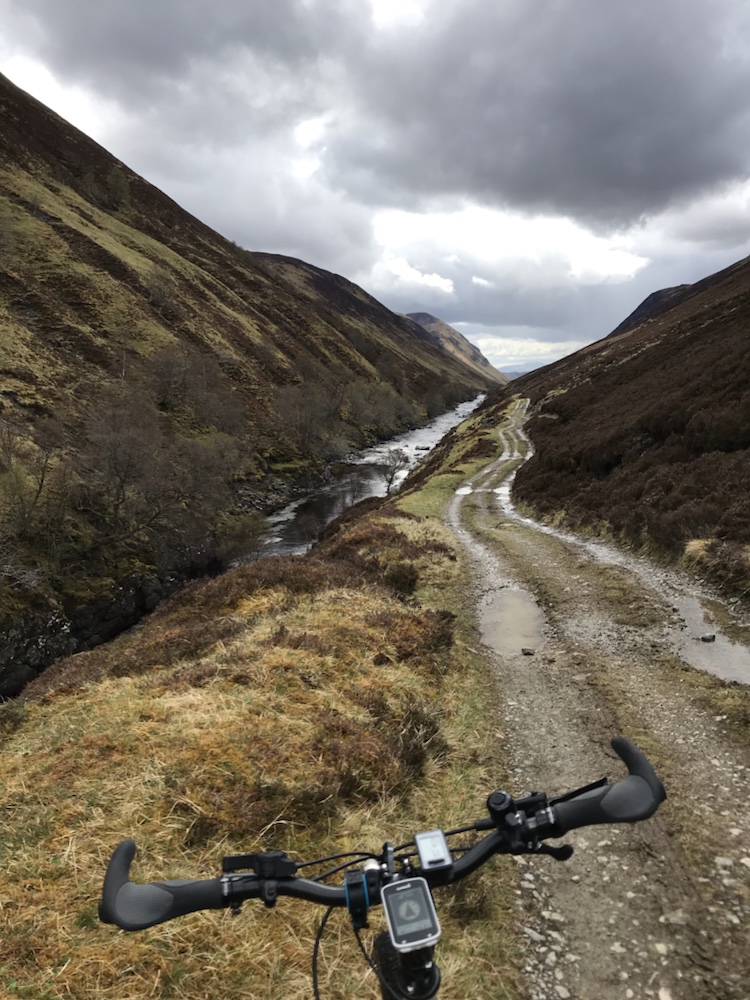
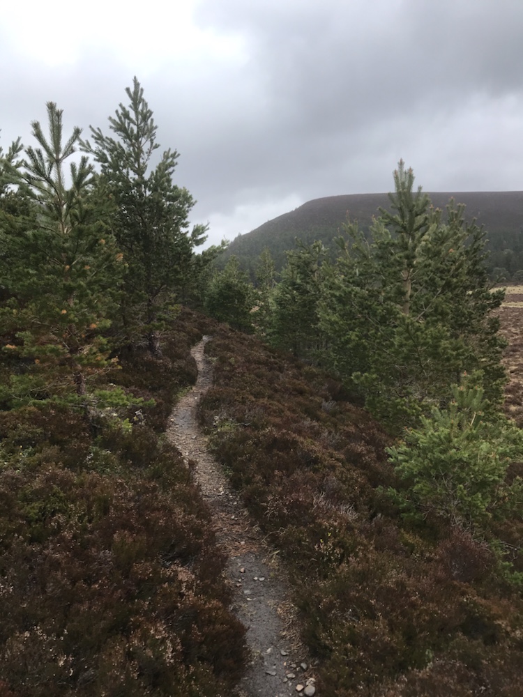
It had rained overnight and was still pouring down as I breakfasted. Eventually it eased so off I cycled off to pick up The Old Logging Trail to Glenmore:

Very pleasant and easy cycling but not a log in sight. Apart from those growing obvs.

At Glenmore Lodge I left the trail and headed north east on a rocky but good track with a fair few walkers and a couple of cyclists.

This track continued the climbing up to:

An Lochan Uaine

Namely the Green Loch. The water is green as folklore says the pixies washed their clothes in it. If I washed mine, it would be a shade of mucky brown. But what is the point in washing clothes when they and you are wet ?

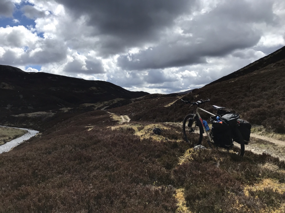
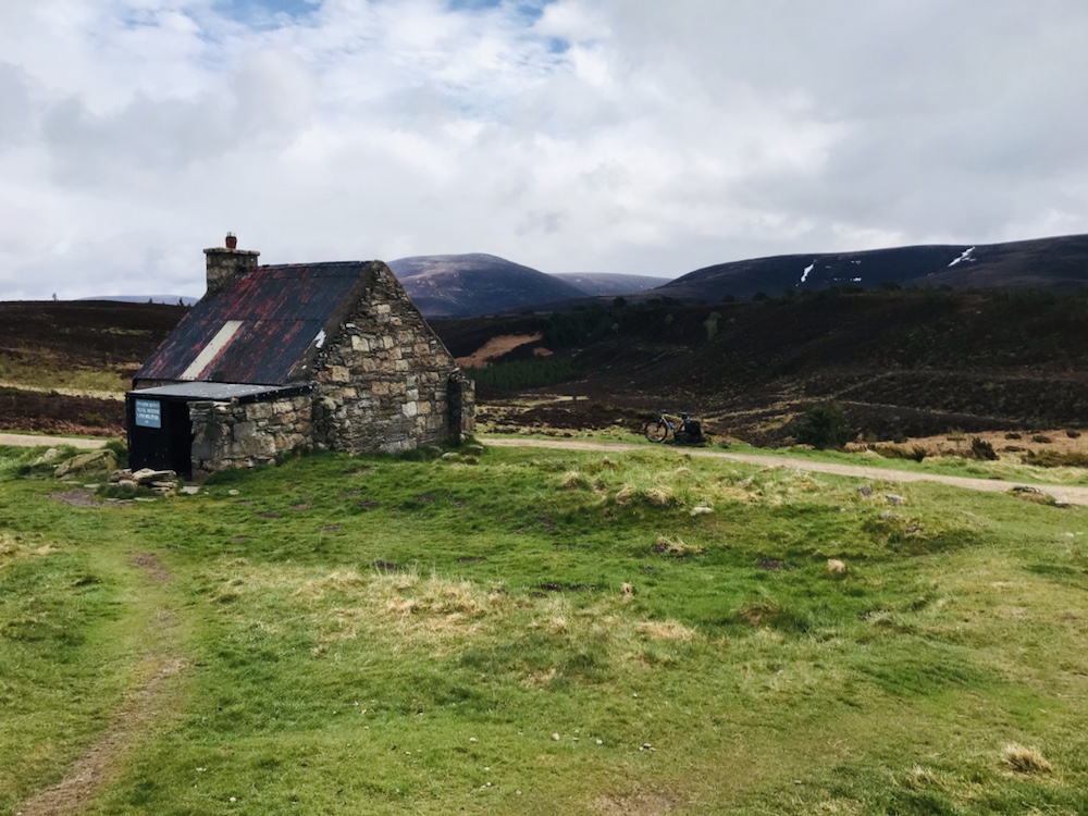
Next the well known Ryvoan Bothy at the start of the eponymous track :

Temporary cessation of the rain too.

From here onwards for several hours I saw no one apart from a land rover which at one point came up behind me at this ford:

I sort of fell in here.

The track was good to cycle on – it goes through the ancient Caledonian pine forest which many years ago before the clearances covered most of these hills for thousands of acres.

Below: lunch spot in the dripping forest. By this time all was very wet and it was hard to keep out of the mud and puddles.

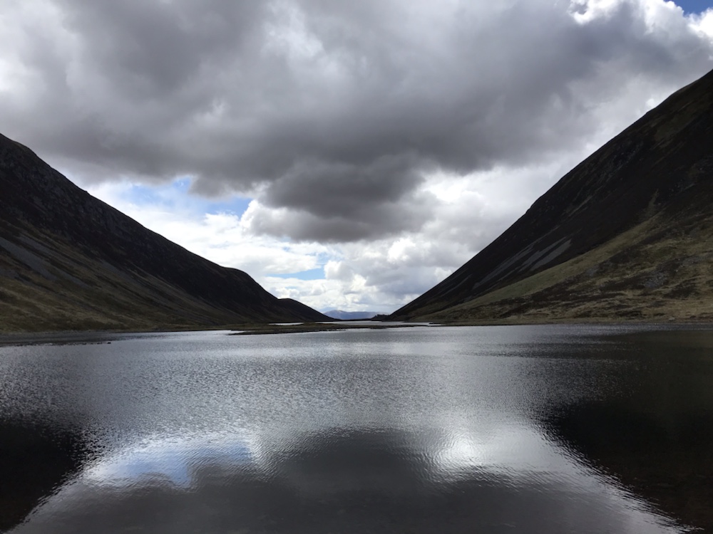
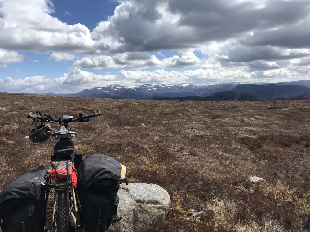
This is a superb forest with so much bird song. On to see the views of the snow covered Northern Cairngorms beyond Loch a’Chnuic :

No chance. Cloud base too low.

Then across a narrow but deep ford and onto what the map/guide described as a rough narrow track that “can be a bit boggy.” Just a bit :

I called this the (almost) impenetrable forest .

It went on for ages. I thought I needed a machete often but I stumbled and pushed my bike through in my sandals as I thought there may be another ford. However eventually it opened out:

Still pushing tho’

I did check my maps a couple of times as I feared I was on the wrong trail; surely this narrow walkers path can’t be right? But after a small panic attack when the maps didn’t update I saw I was heading in the right direction for the Eag Mhor pass:

No bog ! No narrow tree lined path ! Just stoned !

I’ve never cycled anywhere like this before (OK this was more taking my bike for a walk than cycling) but it is a great change from road touring.

As a walker I found a lot of these hill tracks a bit boring in getting to the interesting paths so I convinced myself I now had the best of both worlds.

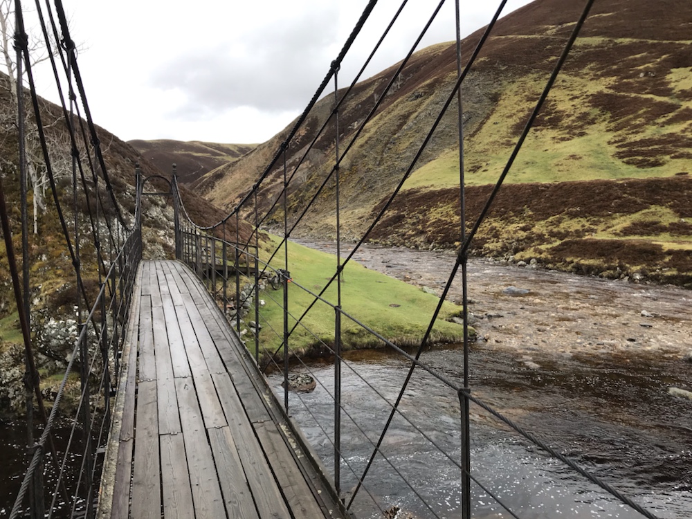
Before I got persuaded myself how lucky I was I got to the Dorback Burn which was the widest and deepest crossing of the whole trip:

But a pussy cat if you have red sandals…best on feet rather than the bike…

And on, ever upwards, through the mud and the bog. A short bit of tarmac then finally:

My cottage is on the side of the Cromdales, the line of hills in the far distance.

Great to be on the home stretch – only 10 or so miles to go and I know the tracks from here. Past another doer-upper :

Letteraitten

And then the descent to the Burn of Brown where there are many abandoned farmhouses.

OK this was a different bike and last July but it looks much better when it’s dry and sunny and the heather is stunning in purple bloom.

I’ve walked around here for many years and always wonder what happened ? Was it mechanisation? Or was the hill farming uneconomic? Has the climate or soil changed or is hunting, shooting and fishing for these estates (as they are farms held on estate leases) more profitable? Combination of all I guess.

Linda and I many years ago went into a couple of these silent, somewhat ghostly houses, found and read old newspaper lining cupboard drawers and thought what happened here? Where did the people go?

Then the fords of the Burn of Brown. Sandals on for the last time. But there were 4 last times as I had to do 4 crossings. By now the heavy rain meant it was in spate.

Then a gate in a wide grassy bog marked the route out:

Thanks Scottish Rights of Way Society (again).

Up out of the bog, onto a sandy estate track and a fast (for me) descent to the road that I followed along the river A’an which took me to the track up to my cottage which, as ever, never fails to enchant.

I heard loud and different birdsong as the track climbed up the side of the Cromdale hills. A young deer ran across my path. So good to be back in this sodden, grey green landscape with the constant sound of the A’an in the valley below me.

Home.

It’s been a great trip; would have been brilliant with better weather but this is Scotland and we had snow just two weeks before. So remote for biking, both stark and beautiful; light like nowhere else , solitude and stillness.

I’m very glad I’ve given off road touring a go again. It’s been quite hard at times but worthwhile; I am fitter and in a minor way I’ve tested myself; this tour requires some fitness/resilience/optimism and a sense of humour. An ability to wield a spanner helps too.

The only mtb tour I’ve done before was 3 days along the South Downs Way, with Roger and Phil over 20 years ago. That was very wet too, albeit in winter.

Phil was an inspirational cyclist (amongst many other things), who I knew for over 40 years. He died far too young of cancer almost two years ago. I thought of him often on this trip; he posted quite a few comments on for example my LEJOG blog. I hope you’ve got internet access to see this Phil. RIP.

Next trip…An Turas Mor I hope.

Next and final post for this trip will be the Epilogue in which I’ll try and set out the techy aspects of what worked with my bike and the kit and what didn’t…

CC – Day 3 – Tue 18 May – Blair Atholl to Aviemore

The best day so far…

42.7 miles – about 18 were off tarmac. Some of those were the usual slow pushing through grassy bog and over some single track with steep drop offs.

Average – highest so far at 8.7mph.

Climbing; about 3,000 ft but most of the time quite imperceptible rather than the lung and thigh busting over the last 2 days.

What made it so good ? The stunning scenery. But breakfast?

Straight to the top; great choices such as kippers, excellent service and the gothic splendour .

So the off. But first opposite the hotel (built in 1830 so not the Victorian construction I thought) is:

Blair Atholl’s war memorial

I found the simplicity of this especially poignant. So many Scottish villages have memorials, mainly Celtic Crosses. So many men died, of famous Scots regiments such as the Black Watch and the Seaforth Highlanders.

On the road:

This was the old A9, the main road to Inverness. Thankfully quiet now.

After a few miles onto National Cycle Route 7:

With a serious warning.

After a few miles I met a bloke from Norwich going South – on JOGLE, the opposite of what I did exactly 7 years ago. We had a good chat. This was great cycling; no traffic and great views of the River Garry and it’s remarkable rock formations.

The cycle track ducks, dives and weaves around the new A9, the rail line and the river. I’ve driven it many times over the last 35 years but never knew how beautiful and quiet this valley is just off the A9.

After 11 miles of this all too easy cycling I crossed the A9 and went up and up, on good estate tracks along the Edendon Glen . I came across a deserted cottage called Badnambiast where I stopped for a snack.

A doer-upper?

Inside:

Perfect birds nest.

Great view from the front door:

The easy track could not last but my luck did. I’d checked the map carefully to avoid boots off sandals on then off etc and saw 5 fords plus big bog in 5 miles. I was prepared to be in sandals for 5+ miles.

But the Gaick estate built concrete bridges over the first 2 fords. I also saw the only person I came across in 3 hours cycling. He was sitting in his digger about to make the landscape look even worse, just like the moon. Bit like parts of Oman.

Over the footbridge and through the bog:

Difficult getting the bike through.

But then single track – unrideable – along Loch an Duin. I do not think I have experienced solitude and stillness like this before.

So remote – but it almost wasn’t .

This was the route originally surveyed for both the road (A9) and rail links to the Highlands but the engineers (Victorian I guess) thought it too difficult so they went over Drumochter. Can’t blame them, I found it hard getting my bike through.

Loch an Duin. No point in more words.

Lunch after an easy ford:

Then on a 4WD track, one of the best I’ve ridden on. I guess not many come this way.

But some lucky fishers do.

Then:

Loch an t-Seillach

Eventually some habitation and this sign:

No frog or toad was injured when I fell off my bike here.

Such great cycling. Only birds to be seen aside from one lizard which ran across in front of me. Glen Tromie is a stunning glen.

Eventually I reached the end of the track and met the road, where I saw this sign:

I’d just cycled the top one.

In Scotland there are no public footpaths as in England & Wales. People have a historic right to use the drove roads – which I had spent the last 2 days on – and now have the right to use hill tracks over almost any hill land.

It’s great; it opens up this fantastic country for many to enjoy but preserves the landowners’ right to exclude or control where necessary – such as for deer stalking.

So I left the estate tracks for NCR7 to my bed for the night at the excellent Rowan Tree, just south of Aviemore, where I have stayed over many years.

I’d seen the weather worsening ahead:

You can see the rain tumbling out of the sky!

Likewise :

On I cycled hoping I’d avoid it. No chance. I got soaked. The forecast said sunny periods and showers; bizarrely I experienced both at the same time. Very odd .

But Loch Insch looked stunning in the rain.

And not long after I arrived to a warm room, good beer, and sea bass:

And a good Sauvignon.

The best day so far in every possible way save the rain for the last hour. Tomorrow ; hopefully a good journey back to Alltnaha but it’s been raining constantly for 5 hours now so I suspect that will make it a bit more difficult.

But its the last day so I don’t care how wet, dirty or tired I get …

CC : Day 2 : Mon 17th May; Braemar to Blair Atholl

First those stats :

31.3 miles travelled (about 2 pushing, the rest cycling).

Average speed : 7.1mph. Slow but hard going is my excuse.

Total ascent: my Garmin and my ‘phone cannot agree. I think about 2,200 ft.

So that breakfast; how did the Braemar Arms do?

Sausage ; poor. Black pudding ; excellent. Overall, just above average.

I gathered up my stuff and went outside. It was raining. Off to the Co-Op for vital sustenance for the challenges ahead. Unfortunately they had virtually no sandwiches left save 3 varieties of chicken. So I choose the in date chicken (as opposed to the salmonella special – not in date).

Up the Dee valley:

A grey green dampness.

The road ran out at the Linn of Dee and the track started.

Boiling, tumbling water .

I was concerned about crossing the Geldie Burn some 5 miles ahead. I’d been warned it was highly dangerous in spate. I checked it out on t’internet which is a mistake – accounts of people roping up etc etc. However:

The Geldie Burn; a pussycat for today only. Not sure my cold feet felt the same.

I was pleased that taking boots and socks off and putting sandals on worked. So socks and boots back on and onwards up the glen.

In my worry/enthusiasm to cross this well known obstacle I’d failed to check the map; there were another 3 full on fords then a long spell of boggy ground so boots off etc etc.

The weather closed in. Sunny periods and showers were forecast; there were just 2 showers but each lasted about 3 hours, and no real sun.

Then the single track began as I made my way up Glen Tilt. Great for walking but impossible to cycle; it was narrow, bumpy, with steep drop offs into the river.

Here I took off the panniers to get across some slippery rock:

So remote; or so it seemed.

Towards the end of this slow, slippery and frankly dangerous in parts but scenic path I met a bloke coming towards me. He was walking Lands End to Cape Wrath (!). We had a good chat and he said I was not far from the Tarf Suspension bridge and warned me that once the estate track started it was full of vehicles for filming with some odd construction.

But first lunch at the Falls of Tarf suspension bridge:

Perfect lunch spot apart from the drizzle.

The suspension bridge was built in 1878 following the drowning of someone in the falls:

The bridge:

The Scottish Rights of Way Society erected it.

Now I could cycle as the estate track began:

Very wet but very good to be cycling not pushing.

Then I met 2 young men who were also walking to Cape Wrath. They warned me that the track had been churned up by the film vehicles for about 4 miles into a muddy morass. No-one would tell them what the film was. A mountain biker on his way to Ballater told me it was for Star Wars.

Very odd in the middle of nowhere. I of course had helmet, flo orange jacket, boots, PPE,
etc.

Some unusual rock formations:

Part being pink marble.

The mud on the track was dreadful . I’d heard that there had been torrential downpours overnight until noon. I got mud all over me, the bike and my kit so once at Blair Atholl I bought a scourer and took the bike to the river for a clean.

Then into the Gothic splendor of the Atholl Arms:

Antlers and claymores all over.

And today, for the first time in many months ; pints indoors!

Almost normal…

Today was supposed to be the easiest day; less distance and less climbing. But the single track was long and slippery, the mud deep and it sprayed up over my jacket, helmet and even my neck.

But it’s been a very good day despite that and the weather; these hours in this remote and beautiful landscape have been magical.

Many more fords tomorrow, more miles and a lot of climbing to look forward to! But we’re drinking and eating indoors so what could possibly go wrong ?!

Cairngorms Carousel: Sun 16th May 2021 – Glenlivet to Braemar

First those vital stats:

Mileage : 32.77 of which I guess half was road, the remainder tracks. I pushed the bike for almost 3 miles.

Average : 7.7mph.

Climb : 2,777 ft.

Fords crossed ; 4. Wet feet : one.

As anyone who has read this drivel before will know I always post a picture of my breakfast. So here it is:

A bit miserable but I’ve only myself to blame. Great view though from my kitchen table.

I’m planning cycling An Turas Mor which is an off road route from Glasgow to Cape Wrath of 360 miles, but it would be foolhardy to just try that with no experience of off road touring.

Searching the ‘net for off road routes brought up Cairngorms Carousel – a 4 day route around, surprisingly, the Cairngorms . I also can start from my front door.

I watched the weather incessantly as it has been so cold in Glenlivet. Just over a week ago we had snow and then very heavy rain. That combined with snow melt meant the rivers and burns became rushing torrents – and the CC route has some serious fords.

Anyway with quite a degree of trepidation – thinking of all that could go wrong and was I fit enough etc etc I set off on my first day.

Le Depart as they say in the Tour de France.

Down my track then tarmac to Tomintoul. Next, estate track south, following the River Avon.

Easy cycling on a good track.

I met a couple of girls on gravel bikes at the first proper ford. Here I left the Avon and went up Glen Builig.

Winding track ,good riding.

Then past Loch Builig on tricky single track which I pushed most of the way.

Too difficult to ride!

Then the climb started up Culardoch, the highest point on the circuit . I found this tough and pushed most of the way. I met a bloke coming towards me who was doing a 10 day trip ending up at the Isle of Harris – mainly off road!

Finally at the top – Lochnagar in the distance and the weather looks good where I’m going.
But not where I was – the rain was pouring down.

The wind suddenly increased so that weather front appeared to be on the move. I set off down the track for what the CC guide-map described as 8 miles of fast, free flowing track. And so it was except on the very steep stony descents I wimped out and braked quite a lot, thinking of Graham and his shattered shoulder after he fell off.

The landscape changed from the bleak mountain moorland to gentle slopes with pine forests.

Miles of rideable tracks.

Then I met someone doing the Cairngorm Loop – about 120 – 140 miles in just 2 days – double my measly target. He hammered down the gravel tracks. The going got easier and then…

first view of Braemar.

A great ride through the Invercauld Estate and after 2 boring miles on the road into Braemar. My room at the Braemar Lodge Hotel:

but best of all a bath…

I feel quite knackered but elated I’ve done the first day. The descents require concentration (OK they scare me) and I spend a lot of time standing up to keep my weight on the back wheel so I don’t spin out. Works the thighs like skiing. But a great day with no rain and minimal headwinds.

This must be the only town in the UK where 98% of the people wandering about are wearing walking boots. Quite bizarre. Must admit I was wearing mine too – desperate to fit in. Alternative was my orange Teva sandals but they do for some reason unknown to me make people snigger.

They don’t have bright lights in Braemar but they do have a fast flowing river:

Off for a pint:

Then another …

The hotel in the background is the Fife Arms. Last time I was there was with Roger about 25 years ago after we walked the 30 something miles from Tomintoul taking mainly the route I’d just cycled. We had a load of pints as it was a long, hard walk and then Linda picked us up.

Outside in the garden of the pub I was in that lovely soft rain you only seem to get in Scotland started to fall. Time for supper…

A change from road touring…mountain/gravel biking.

I bought a Calibre Two Cubed hardtail MTB a year ago, and set it up for off-road touring, which I have not done for 25 years plus, and then only 3 days. I did a few routes in the hills around Tomintoul last summer. Completely different to road cycling – very slow (OK I know I’ll get banter that I’m always slow so now I’ll be an arthritic snail) but it combines walking (some rough tracks mean a lot of pushing) with cycling miles from anywhere with no traffic, great views and fresh air.

At the entrance to Glenlivet Bike Trails:

In 5 hours on one trip I managed just 30 miles and climbed 2,500 ft but such fun. Some on easily rideable tracks:

But also deep vegetation – as here, when the forestry track ran out. It was a struggle to get down there, and I fell off a couple of times. This looking to the Cromdales and my cottage. Great place for mountain biking as miles of tracks accessible from the front door.

I’m now trying a gravel bike – I’ve bought a used Breezer Radar Cafe which is a US design. I’ve modified it for gravel touring by adding a Brooks saddle, rear rack and front fork bottle cages for tools etc. It had the modern 1×10 transmission with 42 rear and 38 front. Very reliable and lighter than the alternatives but not low enough for the steeper hills. So I changed it to a twin crankset of 38/24 which is very low.

Continue reading